Parkfield Coalinga Road – A rustic back road drive over the mountains

Parkfield Coalinga Road
Parkfield Coalinga Road is a beautiful back road drive that extends from the small burg of Parkfield over the mountains and connects with Highway 198 a few miles west of Coalinga. With one end right on the San Andreas Fault, this road passes through prime cattle country, past interesting geology and springtime fields of wildflowers.

On my back roads page I mentioned that I wouldn’t be recommending unpaved roads. Generally, they can be intimidating and the dangers of damaging your vehicle and getting stuck where there is no cell service are real.
I am making an exception in the case of Parkfield Coalinga Road however.
First, only 5 miles of its 19 mile total are unpaved. If you take your time the road is passable most of the time. The times you DON’T want to attempt this road are when it’s raining or when you can’t see the summit of the mountain.
Secondly, regular passenger vehicles and pickups make it over this road all the time.
Finally, I am adding this road because it is so very beautiful as you will see. It is also one of the few places in Central California where within a few yards you can see the mountains of the coastal range to the west (~50 miles) and the Sierra Nevada range to the east (~110 miles, when conditions are clear).
Parkfield Coalinga Road Quick Facts:
- Location: Southeastern Monterey County and western Fresno County
- Name: Maps show “Parkfield-Coalinga Road” in Monterey County and “Parkfield Grade” in Fresno County. The sign at the intersection of Highway 198 reads “Parkfield Grade”.
- Elevation: 1500′ at Parkfield; 3500′ at summit; 1200′ at Highway 198. The unpaved section grade is approximately 6%.
- Condition: A paved and fairly narrow rural road for 14 of its 19 miles. The unpaved section begins at the foot of the mountain on the Monterey side (approx. 5 miles north of Parkfield) and continues unpaved up to the summit at the county line.
- Considerations: The road is narrow, especially up to the summit in both directions with steep drops and no guardrails. Four wheel drive is not absolutely necessary as passenger vehicles make this journey on a regular basis. Slow and attentive driving is required. Keep a watch on the road ahead for opposing traffic. There are a few wide areas where two vehicles can pass. Watch for cattle in the road.
DO NOT attempt this road in the rain or when you cannot see the summit of the mountain. I speak from personal experience that it is not a fun drive under those conditions. Definitely “white knuckle” driving with very poor visibility.
The closest gas stations are in San Miguel (23 miles from Parkfield) or Coalinga (28 miles from Parkfield).
Cell service is spotty and the Parkfield area only supports Verizon.
Motorhomes: I have not checked with either counties’ road department on the advisability of RV’s on this road. Proceed at your own risk.
Views of Parkfield-Coalinga Road

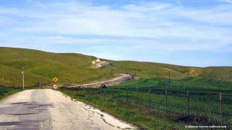
At the southern end of Parkfield Coalinga Road, it begins at the junction of Cholame Road and Vineyard Canyon Road, crossing over Little Cholame Creek and the San Andreas Fault at the bridge pictured above.


End of the paved road – you are heading up and over the mountains in the background. The pavement begins again at the summit.
The gate behind the sign is for the V6 Ranch (website). This is a 20,000+ acre ranch that has many activities, including round-ups and cattle drives in which you can participate.

What this sign means:
- No fences restricting cattle;
- cattle can be on the road;
- drive carefully;
- AND if you hit a beef you are liable.
You may also see the top part of the sign (silhouette of the cow) by itself elsewhere, or with a mileage (e.g. “Next X.x miles”) – they all have the same meaning.


Interesting Sights along Parkfield-Coalinga Road


Wildflowers along Parkfield-Coalinga Road


Elderberry blossoms – if you ever have the opportunity, these are edible. I’ve had them dipped in a pancake batter and fried and they were quite tasty. Supposedly good for you as a tea as well.