Vineyard Canyon Road – A beautiful scenic drive near Paso Robles
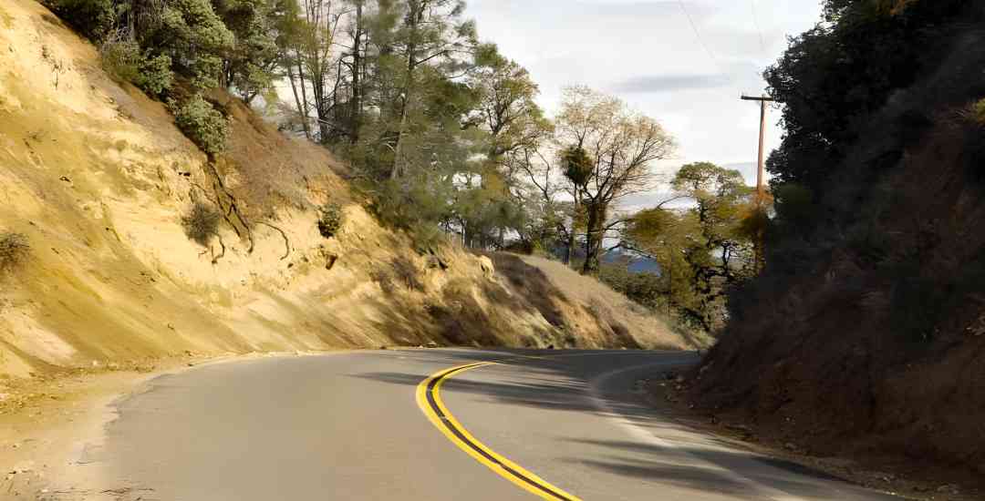
Vineyard Canyon Road – Popular With Bicyclists, Motorcyclists And Antique Car Enthusiasts
Vineyard Canyon Road – Central California is abundantly blessed with many great scenic and backroad drives and this is one of our favorites. Located mainly in Monterey County, this route begins at the northern limit of San Luis Obispo County and ends at the doorstep of Parkfield, right on the San Andreas Fault.
It is a favorite of bicyclists, motorcyclists and antique car enthusiasts since it like taking a step back to a quieter, slower time.
 California as it once was; Nothing here says “twenty-first century”
One of the many great scenic drives found in Central California
Backroad drives can be fun even if there is no particular destination at the end because of the sights along the way. This drive, however, arrives at the small town of Parkfield on the San Andreas Fault.
Famous for the earthquake studies that have been taking place there since the 1980’s, Parkfield does have a cafe (click here for hours) and a lodge. Do note, however, that there is no gas station. You passed the last one in San Miguel.
Please don’t mistake this road with Vineyard Drive which is west of Templeton. That is a lovely road with many available stops along the way for wine tasting. Vineyard Canyon Road isn’t “that” road.
Here is the Google map for the trip:
View Vineyard Canyon Road – a Central California scenic drive in a larger map An aerial view of the western end of Vineyard Canyon; Highway 101 and the Salinas River are at the middle of the photo, left to right. The large green areas trace the path of Vineyard Canyon Road through the center to the bottom. Photo © Jim Gard.
We’re starting this trip in San Miguel, but you could just as easily come into Parkfield from the east, via Highway 46 or 41 and Cholame Valley Road.
You cross over the Salinas River, immediately turn left onto Cross Canyons Road and then in just a few feet, another left onto Indian Valley Road.
This takes you past dry farm hay fields on the right and irrigated alfalfa fields on the left.
After a couple miles the junction with Vineyard Canyon Road appears and you’ll bear to the right.
How Vineyard Canyon Road Got Its Name
You might wonder how this road got its name as there is only one vineyard on this road and that is nearly to Parkfield.
It is derived from the mission days when all this land from the ocean to the San Joaquin Valley belonged to Mission San Miguel. Various agricultural projects were distributed throughout the land grant and just a half mile over the Monterey County line there is a natural free-flowing spring (look for the heavy growth on the right side of the road) which irrigated the mission’s vineyards back in the day.
Today, those fields grow alfalfa, but the name remains.
 The hills in Spring at the beginning of Vineyard Canyon
The lush irrigated farmlands soon give way to dryer grazing and fields where dryland farming relies on the winter’s rain.
You’re likely to encounter wildlife anywhere along this road, but deer and wild pig can frequently be seen helping themselves to the farmer’s handiwork.

A young mule deer mother and her two fawns caught in the act of eating alfalfa
 Wild pigs (and piglets with their backs just visible) grazing in a hay field along Vineyard Canyon Road
It’s worth noting that care should be taken as the deer and other wildlife can leap out in front of your vehicle without warning. I highly recommend that you read my page on How to Drive Backroads before setting out on this or any other drive off the main highways.

Flora And Fauna Alongside Vineyard Canyon Road
Wild turkeys are commonly seen along here, as are quail. Bobcats are a rarer sight and mountain lions rarer still, but a possibility.
In the way of flora, oaks and digger pines dominate the trees. Central California is also home to chamise which covers much of the hills throughout.
Grazing over the years has changed many of the hills from being covered in chamise to hosting grass.
Wildflowers can be found here in the springtime, but not in the abundance of other places like Shell Creek Road to the south. There are nice displays of bush lupines at the summit and poppies all along the road.
 Chamise covered hillsides along Vineyard Canyon Road
At The Summit Of Vineyard Canyon Rd.
Approximately 14 miles from the county line brings you to the summit of this road.
You’ve gradually climbed from 700 feet in elevation at the beginning to 2600 feet here.
From this point, you can see all the way to the Santa Lucia range which separates the Salinas Valley from the Big Sur coast. In the opposite direction you can see eastward to the Temblor Range that separates Central California from the San Joaquin Valley.
If you wish to stop and enjoy the view, be careful as there is only one suitable place to safely stop and park. That is a gated drive just on the southern side of the pass on your left. There aren’t long sight lines here on the road so be cautious.
 The summit of Vineyard Canyon Road
 Looking toward the west with the Santa Lucia range in the distance. On the other side is Big Sur
 Looking north from the summit into the Cholame Valley. The San Andreas Faultline runs through the hills in the distance.
 It doesn’t snow every year, but winter weather and its driving hazards are a reality to consider on this road.
 At the bottom of the grade is the Imusdale cemetery, all that is left of the former settlement of Imusdale.
 Vineyard Canyon Road makes a hard right turn at the bottom of the summit.
 Almost there…but you still need to be alert since there may be a cattle drive ahead around the next curve…
 And there it is! The cowboys will direct you through the herd. Follow their lead.
 The end of the road…the bridge is the beginning of Parkfield-Coalinga Road; Vineyard Canyon Road is to the right and Cholame Valley Road begins to the left.
 The Parkfield Cafe