Cholame Valley Road – wildlife, wildflowers and cattle on the way to Parkfield
Cholame Valley Road
Cholame Valley Road is a short stretch of back road that extends from Highway 46 at the James Dean Memorial Junction to the quiet town of Parkfield. It follows the course of the San Andreas Fault on its journey through the Cholame Valley. To some it might seem as if it were “desolation incarnate”. However, wildlife, wildflowers in season, a solar farm, agriculture, a huge cattle ranch and the remnants of Spanish colonial history are all here.
Cholame Valley Road (its name in San Luis Obispo County) and Cholame Road (its name in Monterey County) are one and the same. Why the two counties couldn’t work together on this, I’m not sure.
However, no one really pays much attention to the slight difference and as you’re driving along in one direction or another, you’ll never notice.
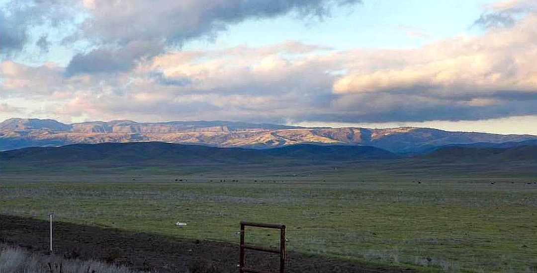
What you will notice are the wide open spaces at the southern end and the oak covered hills closer to Parkfield.
Depending on the season and the travel patterns of the wildlife, there are many splendors of nature that you could encounter. Over the years I’ve managed to capture images of things along this road from nearly every season so you won’t think of this back road as “mind-numbing” and will be on the lookout for the sights it has to share.
Cholame Valley Road Quick Facts:
Location: Northern San Luis Obispo and southern Monterey Counties
Length: 15.5 miles (approx. 5 miles in SLO County and the remainder in Monterey)
Intersections: California Highway 46 at the southeast end (GPS coordinates: 35.734146, -120.286897)
and with
Vineyard Canyon and Parkfield-Coalinga Roads at the northwest end (GPS coordinates: 35.895151, -120.435312).
Conditions: Two lane, paved country road; mostly without centerline; generally in good condition. Sketchy cell service depending on your carrier.
Considerations: Cattle used to free range over the road until about 5 years ago when the Jack Ranch put up electrified fences on either side of the road. However, the free ranging cattle sign is still in place at the SE end which means you should be alert (that’s always true, right?). See my tips for driving back roads here.
Also, there are no gas stations in Parkfield; food service at the Parkfield Cafe is Friday-Sunday.
 Watch out
Cholame Valley Road in the winter
 You shall not pass!
This photo was taken several years ago, and the likes of it certainly hasn’t been seen since that time, due to the drought. But, it does show you how prone to flooding the road is during periods of heavy rain.
Sometimes two miles of Cholame Road can be under 1-2 feet of water which, of course, make it impassable and quite dangerous.
This photo shows the tail end of a flooding event, with the water subsiding and not as bad as it had been. Some of the locals report that there have been years when the road has been closed for a month due to flooding.
 Antelope and snow
The area around Parkfield can also get snow during the winter. Certainly not like other parts of the country, but there are times when 5-6″ is not out of the question.
Wildlife on Cholame Valley Road
 The habitats
Actually, don’t strain your eyes looking for wildlife in this picture, as there isn’t any.
It does show the habitats – the grasslands on the valley floor and the wooded hillsides of the Cholame Hills.
Pronghorn antelope and tule elk like the grasslands, and mule deer prefer the woodlands. As you get further into Monterey County, woodlands become more common.
 Antelope and poppies
This is a “twofer”! Antelope and wildflowers. March 2015 – with the hillsides full of poppies and antelope enjoying a break on the valley floor.
 Big herd of tule elk
Overall, you’re more likely to see antelope than elk. But when the elk show up, they tend to be in big herds. This was taken in July of 2014.
 wild pigs in a hay field
No discussion of wildlife in the Parkfield area would be complete without mentioning wild pigs. They can be found, well, everywhere, eating just about anything.
Wildflowers along Cholame Valley Road
 Poppies gracing a hay field
 Lasthenia californica
 Must be stunning up close…
Solar farm near Cholame Valley Road
The big news last month was the approval of the California Flats Solar Project and the fact that Apple Computer was picking up the tab for half to power its Northern California campuses to the tune of $850 million.
Construction hasn’t begun as of this date (March 2015), but will soon. But don’t drive through the area expecting to see it. This solar farm will be just over the hills and out of sight from the road.
If you go back to the photo of the antelope and the poppies above, California Flats is just over the near hills on which the poppies are found.
 High voltage transmission lines
The power lines shown above will be the ones carrying all the power generated by the solar farm, which is 280 megawatts. A big project, but not the biggest. The Topaz solar farm in the Carrizo Plains is one of the biggest in the world at 550 MW.
Once the construction begins, you won’t have to worry about lots of heavy traffic either, which is good if you’re a cyclist of either variety. All the trucks will be entering off Highway 41 and traversing through the hinterlands of the Jack Ranch instead of Cholame Road.
The Jack Ranch

The above sign can be a bit deceiving – when you are in front of this sign, nearly every bit of land that you can see around you is Jack Ranch land. The ranch comprises 73,000 acres in several counties. Some of it is on the southern side of Highway 46 and down a bit on Bitterwater Road.
The locale that is 7 miles from this sign is the headquarters, just over the Monterey County line.
The heart of this ranch was a Mexican landgrant deeded to Mauricio Gonzales in 1844. Under the prior Spanish rule, this land once belonged to Mission San Miguel. Robert Edgar Jack purchased it in 1869 and he and later his family ran it until 1965 when the Hearst Corporation bought it. The same Hearst as the castle.
The brand for this ranch is a capital “C” inside a circle (for Cholame as that was the name of the Rancho) and is the oldest registered brand in use today in California. It is brand #002 in the brand book.
In addition to the large scale cattle operation on the Jack Ranch, they undertake some agriculture as well. Certainly they grow hay to support the cattle, but at times some of the fields near Cholame Creek can be found growing carrots or other crops.
The San Andreas Fault and Cholame Valley Road
I will spare you from getting overly technical about the San Andreas Fault. Suffice it to say that as you drive along the Cholame Valley, you are following the track of the fault.
The most recent earthquake in Parkfield was in 2004 and the epicenter was roughly where those high voltage power lines cross Cholame Road.
What you may enjoy is an excerpt from a local historian’s book about the Parkfield area, which wouldn’t have been complete without some anecdotal stories about the previous quakes. The late Donalee Thomason’s book is titled Cholama – The Beautiful One, Cholame Valley History and its Pioneer People. You can find the interesting earthquake stories here.